
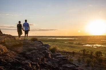
Hike around the soaring rock domes of Kata Tjuta / The Olgas at sunset and watch them glow and change colour with the surrounding desert landscape.
Australia’s Red Centre is home to natural wonder and cultural landmark, Kata Tjuta (the Olgas). Hike around the soaring rock domes, which glow at sunrise and sunset. Located approximately 40km west of Uluru, the ochre-coloured shapes are an intriguing and mesmerising sight.
Take a walk
Choose from a number of walking trails that range from easy strolls to longer, more difficult tracks. At the end of the short walk to the Kata Tjuta dune viewing area you can sit and take in the magnificent panoramic view of the domes.
The Walpa Gorge Walk is a rocky track that rises gently and passes rare plants and leads to a grove of spearwood. The longest of all trails at Kata Tjuta is the Valley of the Winds Walk – a moderately difficult track with breathtaking views. It is very steep in places, but the 7.4km circuit is worth the effort – it takes you between the domes, through creek beds and away from the crowds.
Anangu traditions
Meaning ‘many heads’, Kata Tjuta is sacred to the local Aboriginal Anangu people, who have inhabited the area for more than 22,000 years. It forms an important focus of their spiritual life. As a visitor you can join a cultural tour to learn some of the region’s sacred history and Dreamtime stories.
Uluru–Kata Tjuta National Park is Aboriginal land and jointly managed by its Anangu traditional owners and Parks Australia. The park is recognised by UNESCO as a World Heritage Area for both its natural and cultural values.
Travellers’ stories

Frequently asked questions
-
Kata Tjuta is 495km by road from Alice Springs, or about a 5 hour drive. Commercial bus companies offer Alice Springs to Uluru transfers, or you can join a small group coach or 4WD tour. Direct flights to Ayers Rock Airport are available from some Australian capital cities. Uluru to Kata Tjuta is 58km by road.
-
Kata Tjuta is a Pitjantjatjara Aboriginal word meaning ‘many heads’. This incredible site is only 58km by road from Uluru and is part of the same national park. It’s visually arresting and along with Uluru represents an image and a spirit of place that is the soul of Australia. The collection of 36 domed boulders forms deep valleys and steep gorges.
-
Kata Tjuta is accessible by a sealed road in a 2WD vehicle. There are a number of walks to choose from, ranging from 30 minutes to 4 hours return.
-
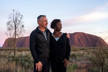
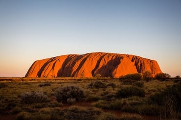
Only 58km from Kata Tjuta is Uluru (Ayers Rock), situated in the Uluru-Kata Tjuta National Park. The world’s largest sandstone monolith is one of the greatest natural wonders of the world.
Uluru is one of Australia’s most recognisable landmarks and is often referred to as the heart of the ‘Red Centre’.
-
The Australian seasons of autumn, winter and spring are the most popular time to visit Kata Tjuta as the temperatures are moderate. Temperatures in summer can average a maximum of 35°C in the day so you’ll need to take plenty of water.
Make sure you see the domes at dawn and dusk. The morning sun lights them in an array of changing colour. At dusk, Kata Tjuta puts on another light showas the sunlight fades.
-
There’s no camping allowed in the Uluru-Kata Tjuta National Park itself, but there are a number of locations nearby where you can camp.
Camping is available at Ayers Rock Resort campground, which is a 10-minute drive from the park. Free camping is available at Curtin Springs station, which is a 1-hour drive, or the Sandy View Rest Area (23-minute drive) on the Lasseter Highway.
-
Walks
There are many walks at Kata Tjuta including the 7.4km Valley of the Winds loop and the 2.6km Walpa Gorge walk.
The alternative name for Kata Tjuta, ‘The Olgas’, comes from the tallest peak, Mt. Olga. The domes are very steep and mostly you will be able to walk amongst the domes and enjoy what nature has to offer.
Valley of the Winds walk
This is the major walk around the Olgas and people rate it highly. It’s a total of about 7.4km but quite steep in parts and takes about 4 hours. A reasonable fitness level is required to do this walk.
On the way you’ll see rare plants that thrive in microclimates amongst the rocks and also a grove of spearwood. Traditional owners used to make spears from this, eat its flowers and use its gum. There are two lookouts and the views are breathtaking. One of the nicest things about this walk is the solitude; you’ll be able to really take in the spirit of this amazing place.
Walpa Gorge walk
If you want a shorter and easier walk than the Valley of the Winds, the Walpa Gorge walk is a great alternative. The walk is very beautiful and is only 2.6km return and takes approximately 1 hour.
Uluru-Kata Tjuta Cultural Centre
Gain an understanding of the spiritual significance of the Kata Tjuta to traditional owners and see how the land furnished them with food, fuel, weapons and medicines. Learn how women and children collected bush foods like desert raisins, bush plums and native figs, and how men used spear throwers to hunt goanna and red kangaroos.
-
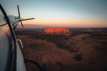
Take a scenic flight
There are both aeroplane and helicopter scenic flights that operate from around Uluru. These give a magnificent perspective of both Kata Tjuta and Uluru.
Mount Conner Lookout
Stop at the Mount Conner Lookout area, which is 156km from Kata Tjuta. Mount Conner is a spectacular flat-topped sandstone mountain that’s 300m high. Mt Conner is closed to the public for hiking and camping, but a stop at the lookout is well worth it.
Kings Canyon
If you’re staying longer in the Red Centre, a stop at Kings Canyon is highly recommended. Take the turnoff to Luritja road to get to Kings Canyon. There are hiking and camping options in the Kings Canyon area.
Holiday deals
Take advantage of these travel deals to help your holiday dollars go further in the NT. See all deals & offers


.jpg?width=370&height=247&fit=crop&format=jpg&auto=webp)


Never miss an NT sale
Sign up to receive the latest news, deals and travel information about the Northern Territory.